 Slpmm 3
Blue Marking
- Go back to the edge of the Etang.
- Veer right towards the wooden footbridge. When you reach the other bank, take the trail on the left along the dam, and go past the water reservoirs. When you reach the first houses, go through the DFCI barrier and veer right towards the roundabout.
Yellow Marking - Take the first exit to the right on Chemin du Plan d’Arenc. Go past the houses and stay on the right.
- At the information board, go through the DFCI barrier and follow the trail through the pine forest. Go around a planted area.
Blue Marking - Go down towards the railway line. After a hairpin bend to the right, follow the tracks and use the little passageway under them.
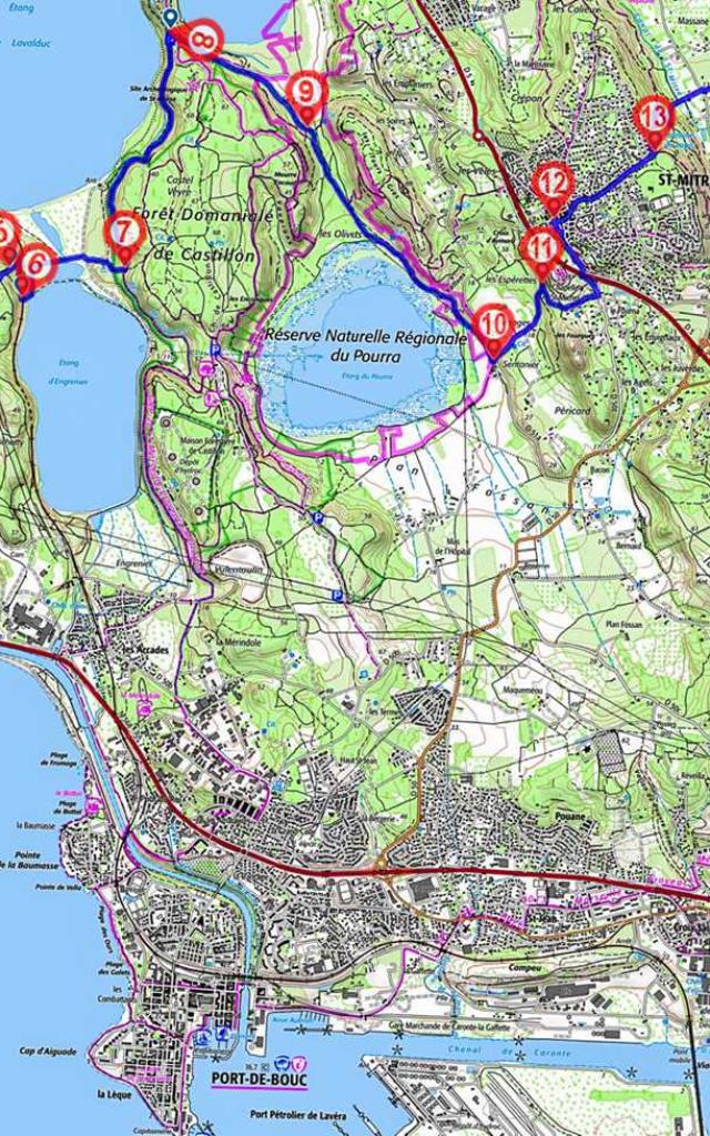
- Stay on the left on the trail going between the ponds. At the crossroads, go straight up towards the Canal des Martigues.
- Take the track to the left along the canal to get to the car park for the Saint-Blaise archaeological site.
- Veer right, take the path around the site to the left beside the D 51 towards an electric pylon.
- Go along the power line to the right to Etang du Pourra. At the 5th pylon, veer away from the line.
- At the crossroads, turn left towards the dry stone wall and cross the road to follow the Vieux Chemin de Fos which goes lightly uphill opposite. 150 metres after the last cabanon, turn right into the path.
- You will come to a housing estate and the D 50z. Go up to your left and use the pedestrian passageway under the D 5. Go across the car park on the left and just before you get to the Mairie take the stairs on the left to go up Rue Louis Brauquier and then Rue des Veles. Cross the little square and turn left into Grand’ Rue.
- After the church, continue to the right towards the square. Take Rue des Paillères, Boulevard de la Fontaine du Loup and Chemin de la Fontaine du Loup.
- When you reach the barrier, continue down to the left and after 100 metres, veer right. At the next crossroads, go round a hairpin bend to the right, go past Fontaine du Loup and then come back to the left, cross the Canal de Saint-Mitre and the road and go between two electricity poles. opposite.
- After the last house, go right towards the olive trees and the Domaine de Mauvejeane. Stay on the right and go round the Collet Long hill. 500 metres after the Domaine, veer left between 2 fields, along a hedge of cypresses, and cross it to the right before the property. Take the hairpin bend and go up to the left on the trail which goes to the right. When you reach the crossing, stay on the right and then go straight on to the Citerne de La Loubière DFCI No. 358.
- Go right and at the crossroads, turn right parallel to the Etang de Berre. Go 900 metres and then down the trail to the left. (Centuries old oak tree). Veer right towards the ruin of Figuerolles and come to the waterfront.
- Turn right, and walk right along the coastline to the beach of Figuerolles. Go inland to follow the trail which runs parallel to the coastline. 500 metres further on, leave the trail to the left and follow the coast path to the first houses. Follow Allée Jean Batiste Clément.
- At the crossroads, go left down Boulevard du Touret de Vallier and then use the path which follows the coastline. Linkup with GR® de Pays 2013 Marseille Provence Métropole.
Yellow/Red Marking - Go through the Base Nautique, and follow the slightly overhanging coastline to the Jardin archéologique de Tholon. Go through it and then go left up Avenue Mozart, and turn left at the end. At the roundabout, take the second exit, Avenue du Président Salvador Allende. After No. 28, leave the road and take the walkway along the bank, go through Parc de La Rode, the square and Place des Aires. Cross the fixed bridge on the left over Canal Baussengue and then Canal Gallifet via the bascule bridge and follow Quai Général-Leclerc. After the Agence immobilière and the opticians, cross Place des Martyrs on the right. When you reach the insurance company (bureau d’assurances), turn left onto Avenue Frédéric-Mistral. After No. 32, take the discreet Traverse Joseph Barthélémy on the right.