 Slpmm 10
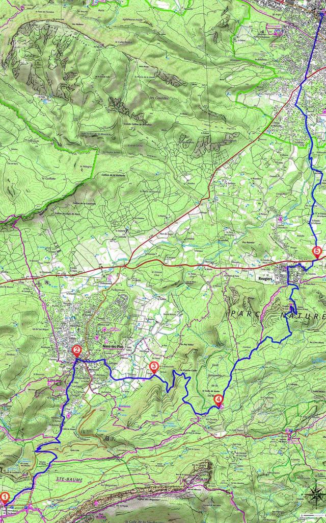
- Go across the D 80 and go slightly to the right in the area of open woodland, go straight on, and to the left of the Cayre building. Come out on the D 80, and walk alongside it for 100 metres until you reach a car park. Come out on the right, go through the barrier of the DFCI S 31 Béguines trail, follow the path parallel to the road for 100 metres and veer right. Go past a water tank, and at the next 2 crossroads, stay on the left. Follow the main trail which veers sharply to the left. Cross the D 80, and go down opposite the signpost. Follow the winding path through the undergrowth on Chemin des Roys, and you will come to the first houses. Separation of GR® 9 and linkup with GR® 9A. Keep going straight on along the road. After the Sermax/Le Tigre factory, take the path to the left behind the farm building, and not long after turn left and then right. Go straight on along Chemin de l’Orge, go past the Chemins de Saint-Esprit and l’Hubac on your left, you will come to a little chapel. Go down Rue de l’Eglise on the right and to the left of the fountain. After the church, Separation from GR® 9A and linkup with GR® de Pays Montagne Sainte-Baume.
Red, Yellow Marking - When you get to the big square with the plane trees, veer right onto Cours Général de Gaulle, and when you get to the end, follow the D 80 for Plan d’Aups, and take the first left on Route de Cauron. Go straight on across the plain, through Les Vanades and when you get to No. 557, turn right on Chemin de Ménarguette, and after No. 217, go up to the right. At the next fork, go left. Go past vineyards, walnut and grain plantations, and past 2 small buildings. After No. 1651, go along beside the wood.
- At the end, veer right, go through the barrier of the DFCI S 28 Barnum trail, go up the main dirt trail, at the beginning on the edge of the wood and then on more open ground. It makes a large turn to the north. At the first crossroads go straight on. Linkup with GR® de Pays Boucle de la Sainte-Baume. Before Before the second crossroads take the path on the left. Separation from GR® de Pays Montagne Sainte-Baume.
- At the crossroads with the main trail, go left along the former dam and the picnic area and then turn right. Go straight on and under the electricity line. Then go right. Separation from GR® de Pays Boucle de la Sainte-Baume.
Blue Marking
Leave the dale by the trail on the right, it goes to the right and then left before joining up with another trail. At the intersection, go up to the right. On the ledge, stay on the right and go towards the water tank and the ruins of Castrum Saint-Jean. Go around the chapel and down to the right. Follow the hairpin bend to the left and go past the oratory. At the crossroads, go right to join up with the road. Go left until you reach the first houses of Rougiers. Go through the barrier of the DFCI S 42 Les Glacières trail. Linkup with GR® de Pays Boucle de la Sainte-Baume. Go down to the right. Seaparation from GR® de Pays Boucle de la Sainte-Baume. At the Stop sign, keep going straight down Rue Sainte Anne. After No. 1 and the fountain on Place de l’Horloge, turn right into Avenue de Brignoles. Go past the church. After the Cave Coopérative La Fraternelle, turn right into Chemin de la Coopérative. At the end, turn right to leave the village, along past the vines. At the crossroads with the D 1, turn right with caution. - Take the first left to La Riperte. Stay on the left, after the first vineyards, go right towards the château and immediately left. Go over the canal and turn left. The Chemin Rural starts to follow the canal and then moves away from it towards a house, along cultivated parcels and then back left towards the Aqueduc du Cauron. Where it meets the main trail, turn right and follow it along the canal. At the third bridge, cross the canal on the left before its passageway and go down Chemin du Canal. At the crossroad turn right onto the D 83. At the next crossroads, veer right onto the D 560. At the roundabout, take the second exit. At the following roundabout, go straight on along the third exit DN 7. In the left-hand bend, go straight on along Rue Gambetta and then left on Rue Colbert. Then, take Rue Denfert Rochereau and Rue Général de Gaulle on the right until you reach the Basilique de Sainte Marie-Madeleine.