 Slpmm 4
- At the MJC, turn left onto Boulevard Émile Zola. At the traffic lights, veer right after the gardens and go up the stairs and opposite onto Boulevard Voltaire, cross Rue Bellevue and go straight ahead between the buildings of the Cité des Deux-Portes. At the end of this passageway, go straight up Rue Sylvia de Luca opposite. At the end of the street, go into the tunnel, past a barrier, onto a trail and stay on the left. Take the wide trail going uphill. At the crossroads, continue on the trail opposite and at the next crossroads, veer right, CB 68 sign. Separation from du GR® de Pays 2013 Marseille Provence Métropole.
Blue Marking - Go down the trail to the right towards the power line in the Vallon du Mistral. Keep the power line to your left. Cross the D 5 at the Col (caution!). Go left at the CB 70 sign, go up the trail to the right, and past some old mills. Go to the right of the electricity pole and down to the left under the electricity line, keeping it on your right. Go straight on. After a wide S-bend, go under the electricity line.
- At the junction, go left down the wide trail (800 metres). Continue straight on until you reach the D 49A, and follow it straight on for 800 metres. At the roundabout, go up Rue du Tilleul opposite. Turn right to come off it and go to the cemetery (cimetière). Pass between the church and the remains of the oppidum and down the stairs and the little street until you reach No 10, and veer right towards the car park on Rue Abbé Villard.
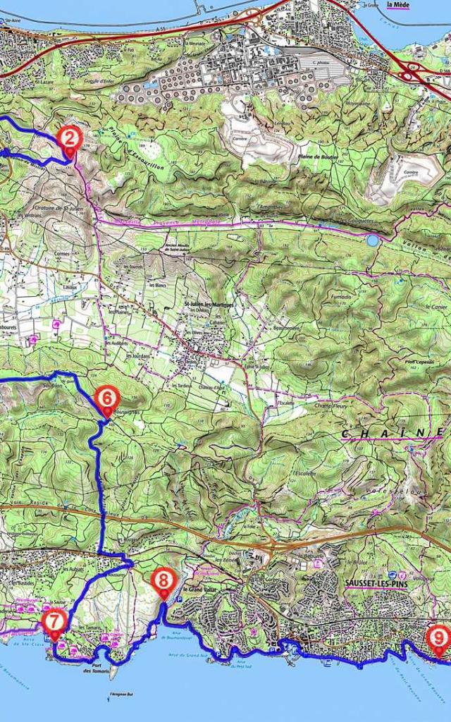
- At the crossroads, go right down Chemin des Gides. At No. 35, stay on the right, after the vines and the big wrought-iron gate, turn left and go towards the ruins of a sheepfold. Go up the path to the right – after a bit it becomes stony. Between 5 and 7 secondary linkup via the waterfront 13 km – 4¼ hours. At the water tank, go right down to the coast and follow it to the Sainte-Croix beach.
- When you reach the water tank, take the trail up to the left for La Gatasse and continue on through the pine forest. After the barrier in the hairpin bend on the surfaced road, (CB 47 sign), veer right and go up the D 49. When you reach the telecommunications antenna, just before the Col de La Gatasse, cross over (caution!). Go straight on along the trail on the plateau. [O> viewpoint]. Go past the water tank and the watchtower and, at the crossroads, turn right and continue along the main trail.
- Turn right before you reach the water tank, and the CB 16 sign and at the next crossroads, take the trail on the left. Go under the power line, through a barrier and take the pipe under the Voie Rapide, continue through the wood and veer left. Go along the railway line, over a little bridge and then over the railway line. When you reach the end of Chemin des Roussures, take the little dirt track on the left which avoids having to cross the road. Go across Chemin des Rouges, CB 15 sign and go right towards the roundabout. Cross Route des Bastides and take the greenway (voie verte) opposite. Go down it, and at the roundabout go towards Sainte-Croix on the path lined with big rocks. Go along past the campsite, down the pedestrian path along the edge of the pine forest and you will come to the Sainte-Croix beach. Go left towards les Chapelles, CB 13 signpost.
- After Chapelle Sainte-Croix (on your left, former 12th-century chapel), continue via the coast along past the campsites, pass near the radar station and go down to the harbour of Les Tamaris and the car park. Cross the road and follow the coast path at the eastern end of the harbour. Go along the coast and past an archaeological site at the end of a little road. Follow the coastline to D 49 (caution!) and the reed bed.
- Go down to the right towards L’Anse de Boumandariel, CB 14 sign. Go along the Promenade du Littoral which will take you to the harbour of Sausset les Pins. Go around the harbour. Continue along the corniche for approx. 1.5 kilometres, until it joins up with RD 5. At the end of the Promenade de la Corniche, go down to the right. Follow the road to Carry le Rouet.
- After the veterinary clinic, turn off the road to the right to go back to the coast. Then follow the coastline to the harbour of Carry, past the Centre Nautique de la Tuilière. You will arrive in the harbour via Plage Fernandel (beach). Go around part of the harbour. Aim left for the stairs, between a brasserie and a restaurant, take them up Rue Jérôme Chapuis towards La Route Bleue, and turn right. As you come out of the bend to the left, turn right down Avenue Gérard Montus which will take you the the beach of Cap Rousset.
- At the end of the beach, go into the Barqueroute housing estate, (private property). Take Allée de Barqueroute. At the crossroads with Allée de la Falaise, go straight on along Allée des Marines. When you reach the car park, there is a little path which takes you to the D5.