 Slpmm 9
- Go past Rue de la Fontaine on your right and, when you come to the cypress at No. 173, go up Rue du Général-Leclerc. At the roundabout, go straight up Rue de Flore. Stay on the left of the square. Before you get to the church go down the steps to the right, up Cours Sudre and along past the public gardens. Turn left onto Rue Dominique Piazza. Go past La Maison de Saint Eloi and the pétanque ground. Go right for Super Gémenos and straight up the path to the left at the bus stop, then veer left onto the cliffside path. Go down left and through a barrier. Cross the D2 carefully and you will come to the car park on the right. Turn right for Super Gémenos and take the path on the left straight away at the bus stop, then veer left on the balcony path (Yellow Marking). Go down to the left and through the barrier. Cross the D2, cautiously, and go into the car park on the right. You meet up with the GR® de Pays 2013.
- Go up through the car park on the right-hand side. Cross the D2 and go into the Parc Départemental de Saint-Pons. Follow a canal and then along the Torrent du Fauge on a lovely shady path. After the ruins of a mill go past the big waterfall, over a bridge on the left and through a passageway through a wall on the right. Go along the River Fauge on the right bank, over the little bridge on the right and up some steps to come out in front of the abbey. Go up left until you reach the DFCI water tank.
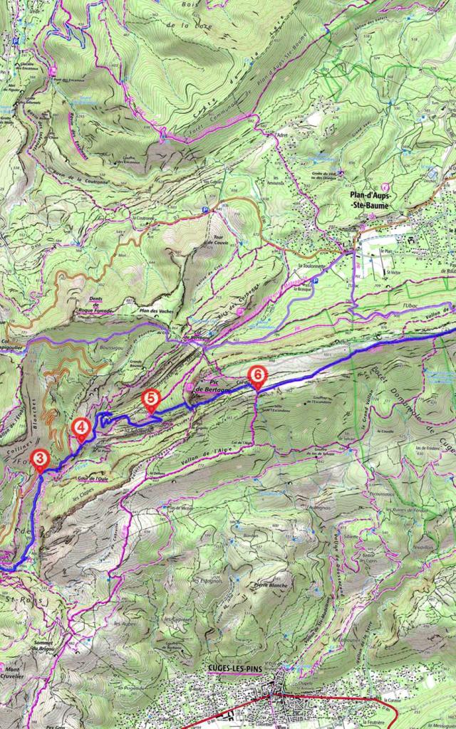
- At the SB 14 sign, take the path up through the garrigue until you reach the road. Go along it on the right for 250 m. On the right you will see a path going down and then up again to the SB 18 sign.
- Take the right-hand path and at the crossroads, stay in the dale. Take the hairpin bends and go up onto a rocky hilltop. At an intersection, go straight on. When you reach the SB 35 sign, go past the Vallon des Crides on the right and past the refuge. Separation from the GR® de Pays 2013 Marseille Provence Métropole and linkup with the GR® de Pays Montagne Sainte Baume.
- At the the SB 34 sign, before the ice house (glacière) go up to the right. When you reach the SB 32 sign, turn right. At the SB 33 sign continue up to the left in a dale at the foot of a cliff towards Col du Fauge. At the SB 30 sign, veer right. Separation from the GR® de Pays Montagne Sainte Baume and linkup with the GR® 98.
White, Red Marking - When you reach the SB 06 sign, veer left and take the path across the plain and then up to the ridge of the Sainte-Baume mountain. Go past the military communications installations and the SB 88 signpost, and you can see in the distance the Chapelle du Saint-Pilon, a little beige cube. Follow White/Red marking to avoid wandering off the trail in this Natura 2000 area. Separation from GR® 98 and linkup with GR® 9.
- When you reach the Col du Saint-Pilon, go down to the left. Keep going to the left and go past the oratories and the Chapelle des Parisiens. Stay on the left to go up to the Grotte Sainte Marie-Madeleine. On the way back, veer sharply to the left, go to the end of the wide path and down the winding path on the right. Go through the exceptional forest of La Sainte-Baume keeping to the main path. When you come out of the forest, turn right and go to l’Hôtellerie de la Sainte-Baume.