 Slpmm 5
1. From the car park, a little path takes you to D5. Go down it on the right for 300 m. After a small handrail, steps on the right will take you to Avenue Jean Bart below the D5 and then the waterfront. Walk along past the beach, turn right in Avenue Blanche Calvet, and then go up to the left on Chemin des Eaux Salées to Chapelle du Rouet. (out and back, visit the site of the chapel). When you reach the top, before the entrance to the Village de Vacances, veer left and opposite the CB 111 barrier, before the bridge, go right between two wire fences on the narrow path beside the railway line. Go down some steps to the Calanque des Eaux Salées. Go across the beach, under the viaduct and take the steps on the other side. At the top of the steps, go under an arch of the viaduct to reach Chemin de la Calanque du Puits. Follow this path for 1 km. When you come out of the l’Escalayolle housing estate, at the crossroads, go right down Chemin de la Madrague de Gignac for 100 metres, take Chemin de la Redonne on the left to where it meets up with Chemin de la Dugué, then turn right and leave it immediately to take Chemin du Pebraïre on the left. Go down to your right to Calanque de la Redonne. When you reach the harbour, turn left onto D 48E for Méjean.
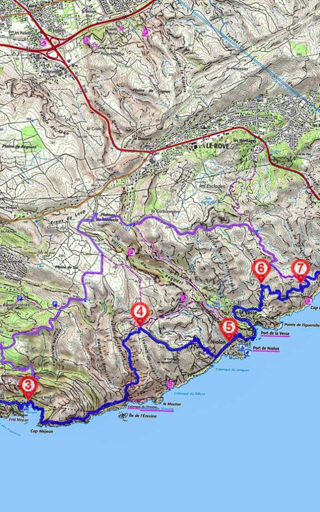
2. Turn right immediately and go up Chemin de Méjean. Keep on going up and, after the roundabout with Avenue Martin, go down beside the railway line and down again to Figuières. At the crossroads, opposite a tunnel, keep going downhill to the right using a short linkup, then up to the left on Avenue des Figuières and Chemin de Méjean. Go down to the harbour of Petit Méjean. Go up again and down to the harbour of Grand Méjean. Between 3 and 7 secondary linkup via Ensuès la Redonne 10 km – 3 hours. When you reach the harbour of Grand Méjean, go up Chemin du Tire-cul on the left.
3. When you reach the harbour of Grand Méjean, take the Chemin du Littoral on the right above the pétanque grounds, follow the coastline, go back towards the railway line, cross over it on a bridge, and veer right. In Calanque de l’Erevine, go down into the little dale and up the stony trail to the left. Go past the first path to your left and, before the ruins of a wall, go up via the second path on the right through the garrigue. At the upper fork, go left.
Yellow Marking
4. Go down to the right. After a ruin, at the first crossroads (where the cliff starts), go past the Fort de Niolon on the left (cliff start), veer slightly left and immediately take the little path downhill to the right. Continue between the rocks and the little dip to the left, veer right, go around the rocks, over a little stone bridge, along past a dry stone wall and back to the railway line. Follow it left towards the harbour of Niolon. Go past a barrier.
Blue Marking
5. Go up the road to the second bend to the left and opposite take the path cut between two rocks. This enables you to cross the overhanging railway line and go down towards the last houses of the Calanque de Niolon. [N Very beautiful viewpoint over the Calanque, the Bay of Marseille and the Frioul islands]. Do not take the path down to the harbour, take the overhanging one on the left. A series of steps takes you down to Calanque de la Vesse. Go left and along the fence of the Parc à Bateaux. Go under the viaduct, straight on and up Chemin de la Carrière. After the houses, go under the concrete footbridge and take the steps on the right. Go up to the left on the cliff path until you reach Le Collet de Figuerolles, at the foot of the Rocher de la Croix rock overlooking the village of La Vesse. When you reach the crossroads, go up to the left. At the end of the dale, you’ll come to a quite large path.
6. Go up to the right on the winding path and, at the crossroads, go down the trail to the right.
7. Veer left on the road. Yellow Marking 200 metres further on, opposite a pine tree, go down a poorly marked path to the right, along the rocky outcrops and then up onto the ridge to reach the coastal path. Stay above the railway line. Go down into the Vallon de l’Establon, across the footbridge which leads to the road.
Blue Marking
8. Turn right, and go along the road until it leaves the Resquiadou road tunnel. Go down along the beaches of Corbières and Port de la Lave. Go past the first roundabout and the stadium. When you reach the marina (Port de Plaisance) and the beach of L’Estaque, after the traffic lights, turn left into Passage du Pataclet after the Pharmacie. Go up Rue Druilhé and then Montée du Cercle on the left. (Church of Saint-Pierre-es-Liens, 19th century).