 Slpmm 7
- Go up Rue de l’Abbaye and turn right into Rue d’Endoume. Go straight on and after No. 41, go left across the square, follow the ramparts on Rue des Lices, and use the steps on the right. Linkup with the GR® de Pays 2013 Marseille Provence Métropole.
Yellow, Red Marking
Go down through Jardin de la Colonne, and come out on Cours Pierre Puget. Separation from the GR® de Pays 2013 Marseille Provence Métropole.
Blue Marking
Go down it, [N Palais de justice], and then Rue Armény, opposite the Préfecture, veer left and cross Place Félix Baret to continue along Rue Saint- Ferréol.
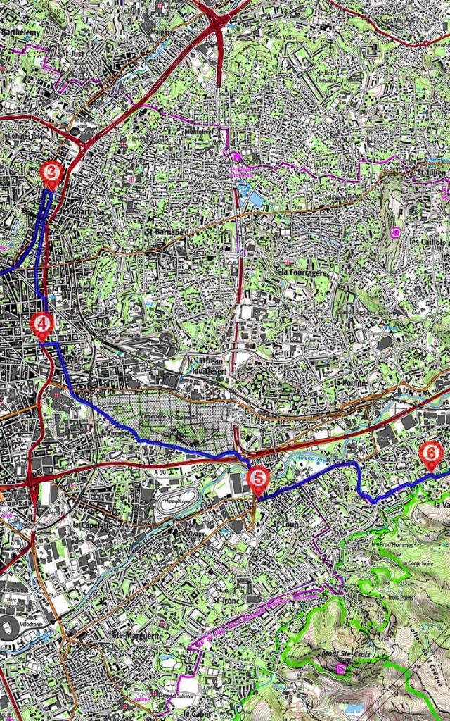
2. Turn right up La Canebière, [N Eglise Saint Vincent de Paul], Boulevard de la Libération and Avenue des Chartreux. Veer right into Rue Pierre Roche. (Eglise des Chartreux).
3. Turn right into Boulevard d’Arras, left into Place Brossolette and right into Rue des 3 frères Carasso. Cross Boulevard de La Blancarde and take Rue du docteur Acquaviva. Where it crosses the tramway, turn left into Avenue du Maréchal Foch. At the swimming pool, (Piscine Vallier), veer right onto Boulevard Sakakini.
4. At the crossroads with Boulevard Chave, veer left and take Rue Jean Martin on the right. At the end, go across Rue Saint-Pierre and go towards Place aux Palmiers opposite, along Chemin de l’Armée d’Afrique, under the railway tracks and along the cemetery wall. At the crossroads after the last florists at Porte Rampal, use the pedestrian facilities to cross the overpass (échangeur Florian) safely to the left-hand side of the footbridge across the River Huveaune just before the big store (Castorama).
5. At the last crossroads on Avenue Florian, turn left on Boulevard de Saint-Loup. Jonction with the GR® de Pays 2013 Marseille Provence Métropole.
Yellow, Red Marking
At No. 240, go into Parc Saint-Cyr on the right and up to the château. As you come out of the park, veer left and go downhill, after the Parc St Cyr bus stop, turn right between the trees towards Chemin Rural No. 34 de la Valbarelle à Saint-Marcel. Go past a stadium, the Cité and Ecole Maternelle Michelis.
6. When you reach the end of Avenue du Pontet, go up a path to the right along the fence to reach the canal (piped) and follow it. At the end of the canal, leave the Résidence through a little gate and continue along beside the canal. After a little bridge made of brick and stone, go up to the right on Traverse Crésus. At the end of the Traverse, turn right up Rue de la Granière for approx. a hundred metres and then take a trail on the left along the allotment gardens (Jardins Ouvriers). When you reach the end of the gardens, go down the steps on the left which will take you to the car park of the Cité des Néréides.
7. Just after the garbage bin storage area, go down the steps to the right, walk up Rue Saint-Clair and go right again onto a wider road going steeply uphill. At No. 68, you will see steps on your right which will take you to Chapelle Notre-Dame de Nazareth. Go straight on and down Montée des Gaulois.
8. Turn right and walk up Boulevard de la Forbine. After a water tank, go past a barrier on the left. The path goes east and then immediately north and then continues east above the Canal de Marseille. At the DFCI CQ 123 barrier, go down Route du Vallon de Chaumery, then right, up Chemin de la Maque, and veer left at No. 29. At the end, go down Chemin du Pic Foch.