Starting at the village of Orpierre, this sports leaning trail alternates between flat and mountain paths. The path climb up evenly, but the way down is steep. At the top : a toposcope and a gorgeous panoramic view of the surrounding alpine peaks.
1 - Start - road
Take the D30 road toward Laragne Montéglin then take the first right turn toward the Princes d'Orange camp site.
Go by the shop " Proxi " and the swimming pool, cross a bridge then proceed left
Crossroad
Turn right and continue on this path.
2 - Camp site - path
Continue going up on the same road, then go along the Princes d'Orange camp site and turn left toward a rocky path after the parking lot.
3 - Crossroad
Turn right (at the post "Chemin de Bouissette - alt. 700 m).
Admire the village of Orpierre, known for its rock climbing sites, overlooked by limestone cliffs.
Continue on this path which goes up slowly - ignore the left and right roads.
4 - Panoramic view of the Céans Valley
5 - Remains of " Paturle " - source
A small source is here to refresh yourselves. To find it, follow the small trail in front of the ruins, the source is down and on the left.
6 - Crossroad
At the 147 sign, proceed forward toward the Col de Beynaves (GR946)
Go off the road and follow a rocky trail.
7 - Crossroad - FFRP post (" au dessus de Paturle – alt. 880 ")
Go right toward Beynaves (2,8 - 1h), follow the GR signs (red and white) going up.
Alternate path : go left (yellow signs) then go up directly to the Rocher St Michel, be careful, the slope is steep : 400 m difference on 1 km - estimated walking time : 1 hour.
8 - Mountain path and viewpoint
Follow the sunny mountail trail with a breathtaking view of the Gorges de Bagnols, go by a bend and follow the GR path going up. When you arrive at the larger path, proceed forward, then turn left 20 m later at a small trail going up in the frest. Make sure not to miss it.
9 - Crossroad - post 175 - path
Go left toward the Rocher St Michel, now follow the yellow signs (around 30 minutes estimated walk and 2 hours for Orpierre). Follow the path.
10 - ONF fence / viewpoint
A beautiful view of the Céans valley on the right
Follow the path behind the fence
Go off the path to reach the smaller trail and reach the top of the Rocher St Michel.
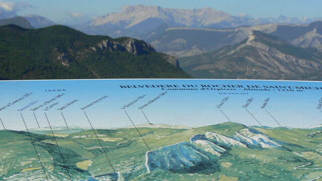
11 - Top of the Rocher Saint-Michel (1200 m) - panoramic view
At the toposcope, turn right until you reach a cairn to admire a much deserved beautiful 360° viewpoint.
Steep descent.
Return to the toposcope and find the sign " Rocher de St Michel - 1200 m " toward Orpierre (3,2 km).
Go back down the trail following the cairns - be careful the descent is slippery, bring good hiking shoes.
Follow the yellow signs, use your hands for difficult parts, until you arrive at a new crossroad.
12 - Crossroad - " La plaine des Bessons – alt. 1030 "
Go right toward " Orpierre par la plaine des Bessons – 2,8km " estimated walking time 50 minutes.
13 - Viewpoint of the village and of the large cliffs of Orpierre (waypoint 35)
Descent by a trail / return trip.
Be careful in the steep slope, the terrain is slippery. Follow the same trail following the yellow signs up to a path, then turn left until the starting path.