See photos (4)

Hiking trail "Les crêtes de Chabre par les Espranons"

Sport, Pedestrian sports, Hiking itinerary in Saléon
16.4 km
5h 30min
Very difficult
  • This trek offers a two-way trip up to the Chabre mountain, with part of the trail on a beautiful ridge. Walk along this ridge to have a beautiful 360° view of the surrounding, at the crossroads of all the Buëch's valleys.

  • 1 - Start and forest trail
    At the hamlet proceed on the road D 330 towar Laragne for about one kilometer then follow the forest trail on the right with an ONF fence, follow the yellow signs. At the sign " clos du chat ", continue forward on the path.

    2 - Viewpoints : cirque of St Genis, Beaumont Mountain, Céans and Eyguians valleys in Orpierre
    Going up the path, you can see the cirque of St Genis on the right. While going up, you can admire different viewpoints.

    Crossroad
    Take the...
    1 - Start and forest trail
    At the hamlet proceed on the road D 330 towar Laragne for about one kilometer then follow the forest trail on the right with an ONF fence, follow the yellow signs. At the sign " clos du chat ", continue forward on the path.

    2 - Viewpoints : cirque of St Genis, Beaumont Mountain, Céans and Eyguians valleys in Orpierre
    Going up the path, you can see the cirque of St Genis on the right. While going up, you can admire different viewpoints.

    Crossroad
    Take the right path and proceed on this road.

    3 - Crossroad post 135 - Chabre / Nossaeg ridges
    At the fork on the left, take the trail toward " la Crête de Chabre " (20 minutes on foot).

    Steep ascent across the forest.
    Ignore the turn and proceed forward. The way up is steep until the ridge. As the trail gets rockier, you will start to see the the view little by little...

    4 - Viewpoint and crossroad
    Go right toward the Chabre peak (2 km - 30 minutes).
    From there you can admire the view of the Buëch valley, from Serres to Laragne, over 15 km.
    Be sure to proceed for more surprises !

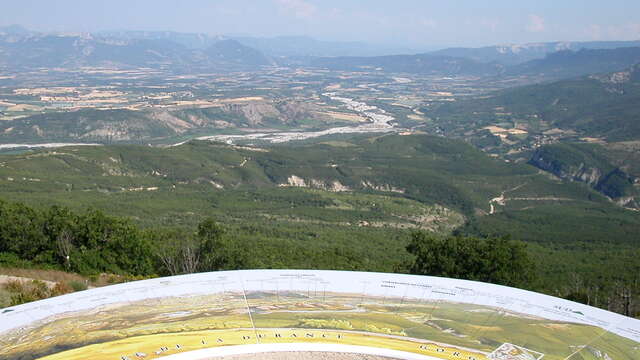
    5 - Ridges - break area and viewpoints
    Various useful spots are on the Chabre ridges : benches, picnic tables, WC and toposcope.

    Toposcope - 360° view
    This toposcope is a must see and full of information to find your way through all the different valleys, villages, mountains, ridges and rocks.

    6 - Peak of Chabre (1352 m)
    To reach the summit, follow the large path then the smaller trail in front of you.

    Return trip
    Take the same path in reverse.
  • Departure
    Saléon
  • Difference in height
    806 m
  • From Laragne or Serres, take the road D 1075 then D 30 (Eyguians / Pont-Lagrand fork), at the first roundabout, take the 3rd exit toward Saléon (D 330). Go by the village, proceed on the D 330 to reach the hamlet of La Tuilière
  • Plain text period
    All year round.

    Subject to favorable weather.
  • Environment
    • In the country
    • Mountain location
  • Documentation
    GPX / KML files allow you to export the trail of your hike to your GPS (or other navigation tool)
  • Accepted customers
    • Level black - very hard
    • For experts / practiced
806 meters of difference in height
  • Maximum altitude : 1355 m
  • Minimum altitude : 582 m
  • Total positive elevation : 806 m
  • Total negative elevation : -806 m
  • Max positive elevation : 569 m
  • Min positive elevation : -579 m
Services
  • Services
    • Pets welcome