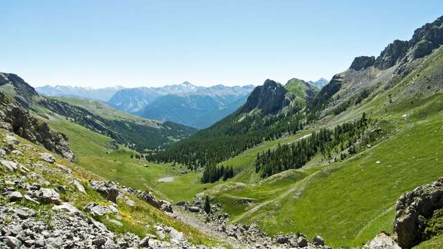
This pretty loop between the Montbrison state forest and the Partias Reserve leads to a magnificent panorama from the Rocher de Roure. A well-preserved itinerary, you'll come across a wide variety of remarkable flowers.
From Puy-Saint-André, follow the asphalt road past the last houses (Lieu dit du Villaret). The road then becomes a wide dirt track. The start of the itinerary is that of the GR50.
This wide track continues flat for about 1.3 kilometers up the mountainside towards the Sacha torrent, giving a fine view of the Tenailles de Montbrison.
The trail ends when you reach the Foret Domaniale de Montbrison (signposted): at this point, take the small path on the left which descends towards the torrent, then cross the Torrent de Sacha footbridge.
On the north-facing slope, the vegetation changes completely, with a multitude of orchids. The narrow path twists and turns through the heart of the forest. After the first 10 hairpin bends, the path is overlooked by the Rocher de Roure. Continue on this path, crossing the Pra Piouzéoui torrent, then negotiating the last hairpin bends to a fork. (approx. 2 km and 280 m ascent from the Torrrent de Sacha footbridge).
At the fork in the road, leave the GR50 and take the right-hand track to the Crête des Alpes for 400 metres (Alt 1838). A magnificent panorama opens up over Briançon and Villard-Saint-Pancrace, with Cime du Mélézin and Grand Peygu opposite.
The path descends steeply through the Bois des Ayes towards the torrent. At the fork, take the right-hand track towards the footbridge.
Take a bend and ignore the footbridge: continue along the torrent, still on the right bank, to begin the return to the footbridge.
Follow the trail back to the Villaret - Puy Saint André parking lot.
Part of the route crosses the Partias Regional Nature Reserve.
To preserve this area, Reserve staff are responsible for enforcing regulations and advising all users.
Savoir Vivre en Réserve :
- Stay on the trails
- Dogs must be kept on a leash
- Picking plants and flowers prohibited
- Bring your own garbage
- Camping and fires prohibited, bivouacs authorized
- Motorized traffic prohibited
- Respect the tranquillity of the site