Le Haut Val

VTT n°11 - Le Haut Val

Sport, Cycling sports, Mountain biking itinerary, Electric mountain bike route in Malijai
Unresolved hours
19.0 km
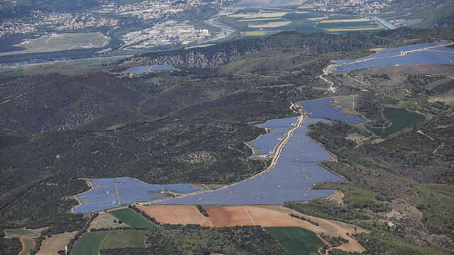
  • Joint departure with route n°10 over 10 km to reach the Haut Val, where the fields of solar panels are located, one of the largest in France. Then you will begin a magnificent descent through a beech forest to the starting point.

  • From the Malijai castle, the route quickly takes you on a tarmacked road with a steep slope that will definitely warm your legs! Then take a path that winds through the oaks, you will continue downhill on a long, very playful path until you reach the departmental road. A second tarmacked climb then you dive into the valley where a steep climb awaits you to reach the Haut Val. A real challenge to take on a mountain bike for non-electric bikers! Cross the Haut Val where the solar panel fields...
    From the Malijai castle, the route quickly takes you on a tarmacked road with a steep slope that will definitely warm your legs! Then take a path that winds through the oaks, you will continue downhill on a long, very playful path until you reach the departmental road. A second tarmacked climb then you dive into the valley where a steep climb awaits you to reach the Haut Val. A real challenge to take on a mountain bike for non-electric bikers! Cross the Haut Val where the solar panel fields are located to tackle a long and pretty descent at the bottom of the valley that will take you back to the starting point.
  • Departure
    Malijai
  • Difference in height
    818 m
  • Environment
    • Forest location
  • Spoken languages
    • French
  • Documentation
    GPX / KML files allow you to export the trail of your hike to your GPS (or other navigation tool)
818 meters of difference in height
Created with Highcharts 6.2.0Distance (km)Altitude (m)0 km2 km4 km6 km8 km10 km12 km14 km16 km18 km400 m500 m600 m700 m800 m900 mHighcharts.com
  • Maximum altitude : 826 m
  • Minimum altitude : 432 m
  • Total positive elevation : 818 m
  • Total negative elevation : -818 m
  • Max positive elevation : 150 m
  • Min positive elevation : -127 m
Services
  • Equipment
    • Free car park
    • Car park
    • Pay car park