
- Voir les favoris
Around lake Serre-Ponçon
Leisure, Tourist routes
in Barcelonnette
135.5
km
-
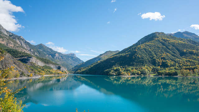
A route that alternates between passes and small balcony roads around the lake. Serre-Ponçon, a true mirror of the surrounding mountains, offers an exceptional spectacle throughout this circuit.
-
This is an unforgettable tourist route, with breathtaking views.
This route, which alternates between passes and small balcony roads around lake Serre-Ponçon, a true mirror of the surrounding mountains, offers an exceptional spectacle all along the way.
Leaving Barcelonnette, the panoramas follow one another on the road that takes you to Le Lauzet and then on to Savines le lac. You then pass through a wild and natural area where the Durance joins the ‘Blanche’. Finish on a picturesque...This is an unforgettable tourist route, with breathtaking views.
This route, which alternates between passes and small balcony roads around lake Serre-Ponçon, a true mirror of the surrounding mountains, offers an exceptional spectacle all along the way.
Leaving Barcelonnette, the panoramas follow one another on the road that takes you to Le Lauzet and then on to Savines le lac. You then pass through a wild and natural area where the Durance joins the ‘Blanche’. Finish on a picturesque little road, the Col des Fillys.
- Departure
- Barcelonnette
-
-
Difference in height
- 3211.61 m
-
-
-
Plain text period
- All year round.
-
-
-
Documentation
- GPX / KML files allow you to export the trail of your hike to your GPS (or other navigation tool)
-
- See all reviews
- 3212 meters of difference in height
-
- Maximum altitude : 1321 m
- Minimum altitude : 657 m
- Total positive elevation : 3212 m
- Total negative elevation : -3212 m
- Max positive elevation : 171 m
- Min positive elevation : -301 m